


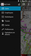


Descripción de MyTrails
No ads even in the free version!
Perfect for hiking, riding, cycling, running, skiing or orienteeringPremium topo mapsUse in-app purchases to subscribe to high-quality, special-purpose maps. Flexible offline mode and competitive pricing.
• OS OpenData (GB)
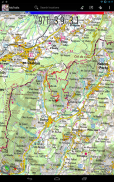
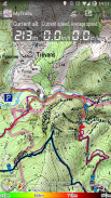
• IGN TOP25, TOP50, Cadastre, Satellite and Littoral (marine maps) (FR)http://www.frogsparks.com/mytrails/ign/• Tour & Trail (Alpujarras, Axarquia, Costa Blanca, La Gomera, Lanzarote, La Palma, Madeira, Mallorca, Menorca, Sierra de Aracena, Tenerife)Full-screen trail map oriented with the built-in compass and GPSKnow exactly which direction you are going.
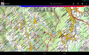
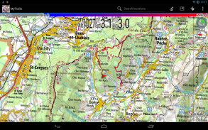
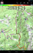
Uncluttered map area, with unobtrusive controls and a traditional scale with track duration and distance.
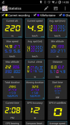
Hardware-accelerated map drawing allows smooth and snappy display even with tens of thousands of track points.Stats40+ stats to choose from!
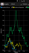
Display them on a dedicated screen (including stats for multiple tracks at once), on the HUD overlaying the map or even on Android Wear.GraphsFreely define axes (over 30 combinations) to visualize your tracks, including elevation profiles, speed vs. time, etc.Free online mapsPick from many built-in online map sources (OpenStreetMap, Yahoo, Bing, Google and many other global and local providers).
Add more map sources using the configurable map sources (URL or WMS).
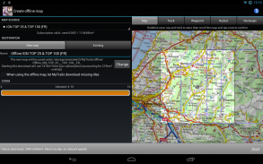
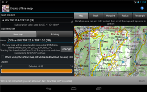
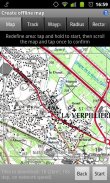
Only premium maps are guaranteed: we may be forced to remove access to any of the free maps if requested by the rights-holders; this is regardless of whether you are using the Pro or Free version.Offline mapsSave battery and data charges.
The map displays instantaneously.
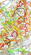
No need to use desktop-based tools to create offline maps, you can do it in MyTrails, in the background.Record GPS tracksVisualize your track at any time and analyse your course during or after the outdoor activity.Display multiple colorized GPS tracks at onceVisualize your previous outings and those uploaded to GPS community sites, so that you always pick a great trail.
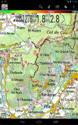
Visualize the key indicators of the track (altitude, speed, rate of ascent, slope, GPS accuracy, etc.) right on the map with a detailed legend.WaypointsManually add waypoints to indicate memorable spots or upcoming turns.
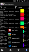
Waypoints are automatically generated when getting directions or when you take a break.Share and archive tracksShare your tracks on My Trails, GPSies, UtagawaVTT and la-trace.com.
Download tracks shared by other users in your vicinity.GesturesEasily switch between active maps by swiping three fingers left to right in the map view.
Pull down the HUD with information on your speed and altitude by swiping three fingers down your screen.Full tablet supportPlan your outing on a large-screen tablet, go out and have fun, and when you're back, view the track in full glory.
Use Dropbox to seamlessly synchronize between devices.
FAQ:http://www.frogsparks.com/faq/Permissions: please see the FAQSin publicidad, incluso en la versión gratuita!
Perfecto para practicar senderismo, montar a caballo, andar en bicicleta, correr, esquiar o de orientación
mapas topográficosPremium
Utilice las compras in-app para suscribirse a alta calidad, mapas de propósito especial. Modo sin conexión flexible y precios competitivos.
• OS OpenData (GB)
• IGN TOP25, TOP50, Catastro, Satélite y Litoral (mapas marinos) (FR)http://www.frogsparks.com/mytrails/ign/• Tour & Trail (Alpujarras, Axarquía, Costa Blanca, La Gomera, Lanzarote, La Palma, Madeira, Mallorca, Menorca, Sierra de Aracena, Tenerife)pantalla completa Mapa de ruta orientada a la brújula y el GPS
Saber exactamente qué dirección se dirige.
Mapa Uncluttered, con controles discretos y una escala tradicional con duración pista y distancia.
Gráfico de la correspondencia con aceleración por hardware permite la visualización suave y ágil, incluso con decenas de miles de puntos de track.Estadísticas
40 + estadísticas para elegir!
Colóquelos en una pantalla dedicada (incluyendo estadísticas para varias pistas a la vez), en el HUD superponer el mapa o incluso en Indumentaria Android.Gráficos
Libremente definir ejes (más de 30 combinaciones) para visualizar sus canciones, incluyendo perfiles de elevación, la velocidad en función del tiempo, etcgratuito mapas en línea
Elija de muchas fuentes en línea del mapa incorporadas (OpenStreetMap, Yahoo, Bing, Google y muchos otros proveedores globales y locales).
Añadir más fuentes de mapas utilizando las fuentes de mapas configurables (URL o WMS).
Solamente los mapas de alta calidad están garantizados: podemos ser forzados a eliminar el acceso a cualquiera de los mapas gratuitos cuando lo soliciten las titulares de derechos; esto es independientemente de si se está utilizando la versión Pro o Libre.
mapasDesconectado
Ahorra los cargos de datos y batería.
El mapa muestra instantáneamente.
No hay necesidad de utilizar herramientas basadas en escritorio para crear mapas fuera de línea, usted puede hacerlo en MyTrails, en el fondo.
seguimientoRecord GPS
Visualice su pista en cualquier momento y analizar su curso durante o después de la actividad al aire libre.mostrar varias rutas GPS coloreada a la vez
Visualice sus salidas anteriores y las subidas a sitios de la comunidad de GPS, para que siempre escoja una gran pista.
Visualice los indicadores clave de la pista (altitud, velocidad, velocidad de ascenso, la pendiente, la precisión del GPS, etc) a la derecha en el mapa con una leyenda detallada.Waypoints
Agregue manualmente waypoints para indicar lugares memorables o los próximos giros.
Los puntos intermedios se generan automáticamente al conseguir direcciones o cuando se toma un descanso.compartir y archivar pistas
Comparte tus pistas en Mis Trails, GPSies, UtagawaVTT y la-trace.com.
Descarga rutas compartidas por otros usuarios de su vecindad.Gestos
Cambie fácilmente entre mapas activos al deslizar tres dedos de izquierda a derecha en la vista de mapa.
Despliegue el HUD con la información de la velocidad y la altitud al deslizar tres dedos por la pantalla.Soporte completo tablet
Planee su excursión en una tableta de pantalla grande, salir y divertirse, y cuando vuelvas, ver la pista en plena gloria.
Utilice Dropbox para sincronizar sin problemas entre los dispositivos.
FAQ:http://www.frogsparks.com/faq/Permisos: Por favor, consulte las preguntas frecuentes
MyTrails - Versión 2.1.0
(17-11-2017)
MyTrails - Información de APK
Version de la app: 2.1.0Paquete: com.frogsparks.mytrailsApps en la misma categoría
Quizá también te interese...


